CHAPTER 7
DIAGNOSING THE ATLANTIC
Probably the most famous mountain range in the entire world is one we cannot even see because it is buried under hundreds and thousands of feet of water.
The Mid-Atlantic Ridge is a broken-up mountain range, running from the north to the south poles under the middle of the Atlantic Ocean.
Scientists today say that it was and is, still being formed by up welling magma from the Earth’s core and that at one time the Americas and Euro/African continents were once joined together and have been slowly spreading apart from each other over the eons of time.
Yes, there is an up welling of magma coming up from the center of the Mid-Atlantic Ridge, however, the Mid-Atlantic Ridge is not being created as scientists teach. Its surface is actually compressing in on itself and is slowly being consumed by the earth's molten core, from the inside out. That and volcanic activity under the other oceans of the world are also causing those oceans to warm, the polar caps to melt and the atmospheric temperature to rise.
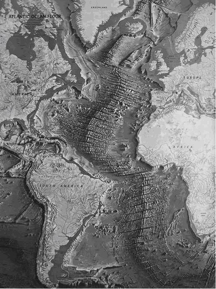
Scientists will show you pictures of the Mid-Atlantic Ridge and point out the ridge lines running parallel to each other in a north-south direction. They will tell you that each ridge line is the result of magma release over a long period of time. They will tell you that the very center of the Atlantic ridge line is the present period of time and the further, outside ridge lines are the oldest; kind of like the rings of a tree.
Traveling to the EXACT opposite side of the Earth from the Mid-Atlantic Ridge you will find our area of impact at the time of the flood. The lowest point on Earth, Challenger Deep, happens to be exactly opposite the Mid-Atlantic Ridge. When the surface of this world was struck by the extraterrestrial object that caused the catastrophe we know as "the flood", the Atlantic area between the present day continents was cracked like an eggshell, from north to south, because of a massive underground tsunami that had spread from point of impact near Challenger Deep. That underground tsunami then traveled around both sides of the globe, like ripples on a pond and met together on the opposite side of the planet at the point where the Mid-Atlantic Ridge is today. The Atlantic area was at one time a solid surface of land but violently exploded upward and outward, from north to south when those two underground tsunamis met head-on into each other.
As the center of that landmass was exploding upward, the outermost sides of that Atlantic landmass fell straight down to the bottom of the water layer that was below its surface. When the center of the Atlantic landmass that had exploded outward began to collapse it naturally began falling from the eastern and western sides first and continued to drop down towards the center of that outward explosion, terminating in the present day north to south ridge, or crack, in the earth’s crust. As that landmass fell through and to the bottom of the water that was beneath it, the water it had displaced, violently welled up through the crack of the Mid-Atlantic Ridge until there was no more, or very little, water under that collapsed surface. The two center edges, or the ridge of the Atlantic Ridge, fell straight down but could not land completely flat like the areas to the east and west of the ridge line; they were sandwiched next to each other and forced to form a peaked series of ridge lines running north and south.
When you see the series of ridges running parallel to each other in a north and south direction you are actually looking at the layers of the outer crust that were formed during the time of creation. If you were to sample the material that makes up those ridge lines you would find them to be made up of the same material that currently layers the exposed surface of the Earth. I also believe you will find that each of the ridge lines are laid out according to their respective individual and relative, specific densities; the outside ridges being less dense than the ridges closer to the center. The Mid-Atlantic Ridge is not the result of volcanic creation. The center of the Mid-Atlantic Ridge IS volcanic however and there IS an up-welling of magma along the split that was caused because of the rupture of the Earth's surface when the Earth was destroyed by the flood described in Genesis. The land masses that now make up the floors of the worlds oceans are no longer being kept cool by a layer of water beneath them and as a result you will find a tremendous amount of volcanic activity on the ocean floor; especially on the floor of the Pacific Ocean, where the original impact occurred. The layers of the Earth are once again being consumed and becoming a part of the molten core at the center of the Earth. The ultimate fate of this world will be that of a consuming fire that will be brought about by the ravenous appetite of a molten core.
In 1949, Professor Frank M. Ewing of Columbia University produced a report of the first expedition he had taken to the Atlantic Ocean and it produced the first of what amounted to a new set of scientific puzzles.
"One was the discovery of prehistoric beach sand…brought up in one case from a depth of two and the other nearly three and one half miles, from any place where beaches exist today." - M. Ewing, "New Discoveries on the Mid-Atlantic Ridge," National Geographic Magazine, Vol. XCVI, No. 5. One of these sand deposits was found 1,200 miles from land.
Sand is a by-product of rock and the action of the ocean waves as they pound the coast; it is also a result of the action of rain, wind and the combinations of heat and cold. The temperature on the deep bottom of the ocean is constant and there is very little to no current at those depths. Because of that consistency, mid-ocean bottoms are made up of silt so fine that the particles can be suspended in the ocean water for a long time before they sink to the bottom. There should be no coarse sand on the mid-ocean floor because sand is native to land areas and the continental shelf.
Because of these circumstances, Professor Ewing concluded, "Either the land must have sunk two or three miles, or the sea once must have been two to three miles lower than now. Either conclusion is startling. If the sea was once two miles lower, where could all the extra water have gone?" To the surface, naturally.
Geology presents, as truth, that the beds of the oceans of the world have not changed except for encroachment on lower continental areas of land. Because of that understanding, it is difficult for geology to accept the idea that the bottoms of the oceans were once dry land at some time in the past.
Professor Ewing also discovered that there were "thousands of feet of sediments on the foothills of the Mid-Atlantic Ridge, Surprisingly, however, we have found that in the great flat basins on either side of the Ridge, this sediment appears to be less than 100 feet thick. Always it had been thought that the sediment must be extremely thick, since it had been accumulating for countless ages…But on the level basins that flank the Mid-Atlantic Ridge our signals reflected from the bottom mud and from bedrock came back too close together to measure the time between them…They show the sediment in the basins is less than 100 feet thick."
Ewing's discoveries indicate that the bottom of the Atlantic Ocean, on both sides of the Ridge, are of recent formation and that at some time in the not too distant past there are many places where the Atlantic Ocean is today where dry land used to be.
DIAGNOSING THE ATLANTIC
Probably the most famous mountain range in the entire world is one we cannot even see because it is buried under hundreds and thousands of feet of water.
The Mid-Atlantic Ridge is a broken-up mountain range, running from the north to the south poles under the middle of the Atlantic Ocean.
Scientists today say that it was and is, still being formed by up welling magma from the Earth’s core and that at one time the Americas and Euro/African continents were once joined together and have been slowly spreading apart from each other over the eons of time.
Yes, there is an up welling of magma coming up from the center of the Mid-Atlantic Ridge, however, the Mid-Atlantic Ridge is not being created as scientists teach. Its surface is actually compressing in on itself and is slowly being consumed by the earth's molten core, from the inside out. That and volcanic activity under the other oceans of the world are also causing those oceans to warm, the polar caps to melt and the atmospheric temperature to rise.
Scientists will show you pictures of the Mid-Atlantic Ridge and point out the ridge lines running parallel to each other in a north-south direction. They will tell you that each ridge line is the result of magma release over a long period of time. They will tell you that the very center of the Atlantic ridge line is the present period of time and the further, outside ridge lines are the oldest; kind of like the rings of a tree.
Traveling to the EXACT opposite side of the Earth from the Mid-Atlantic Ridge you will find our area of impact at the time of the flood. The lowest point on Earth, Challenger Deep, happens to be exactly opposite the Mid-Atlantic Ridge. When the surface of this world was struck by the extraterrestrial object that caused the catastrophe we know as "the flood", the Atlantic area between the present day continents was cracked like an eggshell, from north to south, because of a massive underground tsunami that had spread from point of impact near Challenger Deep. That underground tsunami then traveled around both sides of the globe, like ripples on a pond and met together on the opposite side of the planet at the point where the Mid-Atlantic Ridge is today. The Atlantic area was at one time a solid surface of land but violently exploded upward and outward, from north to south when those two underground tsunamis met head-on into each other.
As the center of that landmass was exploding upward, the outermost sides of that Atlantic landmass fell straight down to the bottom of the water layer that was below its surface. When the center of the Atlantic landmass that had exploded outward began to collapse it naturally began falling from the eastern and western sides first and continued to drop down towards the center of that outward explosion, terminating in the present day north to south ridge, or crack, in the earth’s crust. As that landmass fell through and to the bottom of the water that was beneath it, the water it had displaced, violently welled up through the crack of the Mid-Atlantic Ridge until there was no more, or very little, water under that collapsed surface. The two center edges, or the ridge of the Atlantic Ridge, fell straight down but could not land completely flat like the areas to the east and west of the ridge line; they were sandwiched next to each other and forced to form a peaked series of ridge lines running north and south.
When you see the series of ridges running parallel to each other in a north and south direction you are actually looking at the layers of the outer crust that were formed during the time of creation. If you were to sample the material that makes up those ridge lines you would find them to be made up of the same material that currently layers the exposed surface of the Earth. I also believe you will find that each of the ridge lines are laid out according to their respective individual and relative, specific densities; the outside ridges being less dense than the ridges closer to the center. The Mid-Atlantic Ridge is not the result of volcanic creation. The center of the Mid-Atlantic Ridge IS volcanic however and there IS an up-welling of magma along the split that was caused because of the rupture of the Earth's surface when the Earth was destroyed by the flood described in Genesis. The land masses that now make up the floors of the worlds oceans are no longer being kept cool by a layer of water beneath them and as a result you will find a tremendous amount of volcanic activity on the ocean floor; especially on the floor of the Pacific Ocean, where the original impact occurred. The layers of the Earth are once again being consumed and becoming a part of the molten core at the center of the Earth. The ultimate fate of this world will be that of a consuming fire that will be brought about by the ravenous appetite of a molten core.
In 1949, Professor Frank M. Ewing of Columbia University produced a report of the first expedition he had taken to the Atlantic Ocean and it produced the first of what amounted to a new set of scientific puzzles.
"One was the discovery of prehistoric beach sand…brought up in one case from a depth of two and the other nearly three and one half miles, from any place where beaches exist today." - M. Ewing, "New Discoveries on the Mid-Atlantic Ridge," National Geographic Magazine, Vol. XCVI, No. 5. One of these sand deposits was found 1,200 miles from land.
Sand is a by-product of rock and the action of the ocean waves as they pound the coast; it is also a result of the action of rain, wind and the combinations of heat and cold. The temperature on the deep bottom of the ocean is constant and there is very little to no current at those depths. Because of that consistency, mid-ocean bottoms are made up of silt so fine that the particles can be suspended in the ocean water for a long time before they sink to the bottom. There should be no coarse sand on the mid-ocean floor because sand is native to land areas and the continental shelf.
Because of these circumstances, Professor Ewing concluded, "Either the land must have sunk two or three miles, or the sea once must have been two to three miles lower than now. Either conclusion is startling. If the sea was once two miles lower, where could all the extra water have gone?" To the surface, naturally.
Geology presents, as truth, that the beds of the oceans of the world have not changed except for encroachment on lower continental areas of land. Because of that understanding, it is difficult for geology to accept the idea that the bottoms of the oceans were once dry land at some time in the past.
Professor Ewing also discovered that there were "thousands of feet of sediments on the foothills of the Mid-Atlantic Ridge, Surprisingly, however, we have found that in the great flat basins on either side of the Ridge, this sediment appears to be less than 100 feet thick. Always it had been thought that the sediment must be extremely thick, since it had been accumulating for countless ages…But on the level basins that flank the Mid-Atlantic Ridge our signals reflected from the bottom mud and from bedrock came back too close together to measure the time between them…They show the sediment in the basins is less than 100 feet thick."
Ewing's discoveries indicate that the bottom of the Atlantic Ocean, on both sides of the Ridge, are of recent formation and that at some time in the not too distant past there are many places where the Atlantic Ocean is today where dry land used to be.
 MID-ATLANTIC RIDGE - NATIONAL GEOGRAPHIC
Because of the devastating impact the Earth received the angle and rotation of its axis was disturbed for an unknown period of time. On the ocean floor map you can also see how the planet was subjected to a severe twisting effect. The rotational motion of the earth was drastically altered and resulted in the land area at the equator continuing to move as the result of inertia. The rotation of the Earth's core was momentarily and drastically slowed while the surface of the planet continued to move because of the incredible amount of forward movement that the Earth produced. Because of that disruption in the rotation of the Earth you can also understand now how parts of the Earth could easily have been subjected to the dark, cold effects of space for an extended period of time, and froze, causing the effects of the ice age we are all familiar with. At that time and in those areas where severe ice development is in evidence some of the animal life that were destroyed as a result of the impact were effectively flash frozen in a very short period of time.
We mine coalfields for energy and hardly think about where these deposits of coal come from. If my biology knowledge is still current I believe it takes approximately twelve to fifteen FEET of organic material to produce one INCH of compressed coal; the tremendous amount of vegetation from this greenhouse the Earth used to be would have been more than enough to supply those vast deposits of coal. The United States has the largest reserves with 22% of the world's coal. The Powder River Basin of Wyoming and Montana is the site of the thickest and most extensive coal field. Coal seams found in Wyoming are from 101 to 200 feet thick and a layer of coal in the Lake DeSmet area of Wyoming is 246 feet thick at its largest point; making it the second thickest coal seam in the world. The total amount of coal in the Powder River Basin has been estimated to contain about 2,645 trillion pounds. Now, consider the amount of coal deposits throughout the world and let your mind wander over where all of this material for compressed coal came from. Also let your mind wander over the thought that the coal is consistently uniform throughout its thickness and is therefore not an accumulation that developed over millions of years.
The effects of the underground “tsunami" did not end with the collision that resulted in the formation of the Mid-Atlantic Ridge. Like ripples in a pond, those underground and now above ground "ripples" crossed, crisscrossed and collide with each other for quite a while until settling down to a comparative calmness. The ripple effect of that collision resulted in the surface of some parts of the Earth being flopped over onto another surface of the Earth, just like an omelet, and with other landmass areas being folded and compressed together, accordion-like, in various degrees of position. When the "dust" finally settled the dense vegetation of one surface had been pressed into the dense vegetation of another surface and the result, because of the tremendous weight of the surface material above or alongside, compressing all that organic material together, is the coal we mine today.
There are also areas on the Earth where tremendous amounts of vegetative flotsam (floating, massed together debris as a result of the destruction) had been quickly covered by large amounts sedimentary material. The weight and pressure of that material also turned the vegetation that was buried into large coal and oil deposits.
This planet’s surface is continuing to settle since those catastrophic events. Pockets of water and empty caverns, deep underground, are constantly being displaced by the weight of the heavier earth. The continental areas of the Earth are slowly being forced to the center of its mass by the relentless effects of gravity. As these underground caverns collapse and the layers of the earth's crust continue to shrink, move over and crush into one another (plate tectonics), massive earthquakes are the result.
As for collapsing underground caverns, a prime example of what I am talking about is when the great Lisbon Earthquake happened on November 1, 1755. It has been rated as a 9 on the Richter scale and was centered in the Atlantic Ocean, about 120 miles WSW of Cape St. Vincent, Portugal. The shaking lasted up to 6 minutes and consisted of three distinct jolts.
There were events taking place just prior to the earthquake which substantiate my belief in the displacement of water pockets and the collapsing of underground caverns that at one time used to be large, water-filled pockets deep underground; trapped pockets of water from the strata that existed at the time of creation.
Just before the earthquake, the Atlantic waters off the coast of Portugal and Spain were reported as being extremely muddy, stirred-up, dark and sedimentary; the water level in many wells of Spain fell or completely dried up and water flow in the springs of those areas either decreased or completely stopped just before the earthquake.
The gravitational effect of the heavy surface of the planet was causing tremendous pressure on a vast underground cavern of water. As a result that underground cavern of water ruptured off the coasts of Portugal and Spain; that underground water was then forced up through the rupture on the floor of the Atlantic Ocean, causing the waters of the ocean to become stirred and muddy. Because of that rupture the waters of the underground water cavern, that supplied the wells, springs and fountains in the areas of Spain and Portugal were no longer pressurized enough to continue filling those wells, springs and fountains.
When the pressure of the surface above the now ruptured and unpressurized underground cavern grew great enough, it resulted in a quick and devastating collapsed, causing a massive earthquake that killed up to 100,000 people worldwide. The shock waves from the earthquake were felt in Europe and as far away as Finland and Northern Africa. The displacement of land below the surface of the ocean also caused a 66-foot tsunami that struck the coast of North Africa and swept the coasts of Martinique and Barbados on the other side of the Atlantic. A 10-foot tsunami hit the southern English coastline and the west coast of Ireland.
By now, you should have a good idea of what I am trying to explain in regards to the composition of the Earth before the flood. You should also be able to see how the Earth was effectively decimated during and after the flood and how it came to be in its present condition.
Before the devastation of the flood, there was plenty of warning given to the people who lived on the Earth. The large majority of those who were warned by Noah considered him to be nothing more than a delusional, religious fanatic. If those people had believed the warnings that Noah had given them then God would gladly have instituted a plan to save every person who lived during that time, but human nature, being what it is, does not believe it needs to listen to the voice of God. We are smart enough to know what is going on, and we can take care of ourselves, thank you very much, without having to develop a "mental crutch", or “opiate”, like God, to tell us what to be concerned with.
In spite of what people might think, I believe the hand of God directed the planetary body that struck and bounced off this Earth. Without God’s intervention, this world would have ceased to exist.
The impact turned out to be a glancing blow instead of a direct blow; otherwise, the hydraulic action of the water under the surface of the Earth would have been “explosive” to the point that the water would have violently traveled out, or exploded, equally in all directions, taking most, if not all, of the planetary material with it into space. There would be nothing left in the orbital path of the Earth but a smudge of scattered debris that would continue to orbit the sun as the Kuiper Belt and Oort Cloud do.
A head-on collision absorbs one hundred percent of the energy created by the impact. Fortunately for this planet and the life that survived the impact, only a fraction of that energy was absorbed as the colliding object glanced off our planet and continued on, into space.
Another fortunate result of the glancing collision was that the nuclear furnace at the center of this Earth remained pretty much intact. I believe it was momentarily breached however. The results of the large amount of water below the surface hitting the hot center of that furnace would be apparent. There would have been tremendous explosions as massive amounts of water and surface material violently exploded upward when that large volume of water reacted with the disturbed molten core.
Look at a global map, one that shows the surface detail of the world’s oceans. When you view the area of the Pacific Ocean, the area of Challenger Deep, the Himalayan Range of Asia and the amount of destruction that flowed across the Asian and European Continents, traveling in a northern and westerly direction, you can easily see how debris from the collision that caused the biblical deluge was scattered for thousands of miles in every direction.